LEADING

THE WAY

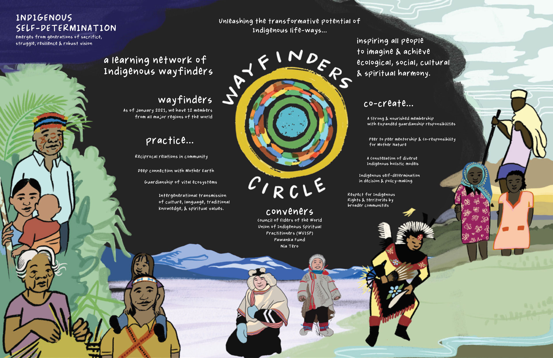
Wayfinding has been a way of life shared by the vast majority of Indigenous Peoples. Today, in a time of unprecedented global change, these wayfinding skills and practices are more important than ever. Reciprocal relations with community, deep connection with Mother Earth, and guardianship of traditional lands and waters are forms of ancestral knowledge that are transmitted from one generation to the next. this wayfinding wisdom is a key to survival as well as resilience as we struggle to maintain Indigenous Peoples’ identity and self-determination.

The Wayfinders Circle supports and gathers Indigenous guardians from around the world who protect their lands, waters, and territories. It is also a learning network dedicated to investing in Indigenous Wayfinders and sharing possible pathways for human societies to achieve ecological, social, cultural and spiritual harmony. 

ubicacion

Where are we?

Explore our territories by clicking the markers.

2022 Annual Report

In this report on the activities of the Wayfinders Circle throughout 2022, we invite you to learn about some of the details on the exciting advances we’ve made, as well as the challenges and lessons we’ve learned.

UNPFII 2022 Side Event Recording

Indigenous Governance: Wayfinders Circle Learnings

Here is the recording of the Wayfinders Circle side event at the 21st session of the United Nations Permanent Forum on Indigenous Issues in New York, where the Wayfinders Circle members shared their stories, governance systems, and contributions towards each other’s shared learnings and efforts in Indigenous guardianship. The event also served to present the recently developed governance report, which is available below.

CONVENERS

ubicacion

Where are we?

Explore our territories by clicking the markers.

img_mapa_wayfinders_home_movil

CONVENERS

Warddeken

Name:

Warddeken Land Management

Geographic Location:

Australia

(Arnhem Land, Northern Territory)

Size of Territory:

1,394,951 ha

(Warddeken Indigenous Protected Area)

Population:

----

Wampis Nation

Name:

Wampis Nation

Geographic Location:

Peru

(Peruvian Amazon border region with Ecuador)

Size of Territory:

~1,327,760 ha

Population:

~15,300

Udege

Name:

Udege

Geographic Location:

Primorsky Krai and Khabarovsk Krai regions

(southeastern Russia)

Size of Territory:

Approx. 2 million hectares

Population:

1700 inhabitants

Sungai Utik

Name:

Dayak Iban Menua Sungai Utik

Geographic Location:

Kapuas Hulu, West Kalimantan, Indonesia

(South East Asia)

Size of Territory:

10,087 ha

Population:

279

Sámiid Riikkasearvi

Name:

Sámiid Riikkasearvi (RSR)

(National association of Sámi in Sweden)

Geographic Location:

Sweden

(Arctic Region)

Size of Territory:

Approx. one-third of the surface of Sweden

Population:

Between 20,000 - 40,000

Rapa Nui

Name:

Rapa Nui

Geographic Location:

Easter Island, Chile

Size of Territory:

163.6 sq km

Population:

8,000 inhabitants approx.

(Last official census of 2017 says 7,750 inhabitants)

Native American Land Conservancy

Name:

Native American Land Conservancy

Geographic Location:

USA

(Southern California)

Size of Territory:

NALC serve an intertribal area

greater than 40,000 square miles
(over 100,000 sq km)

Population:

200,000 (California)

Mayangna Nation

Name:

Mayangna Nation

Geographic Location:

Nicaragua

(North Caribbean Coast Autonomous Region)

Size of Territory:

8,100 km2

Population:

45,000

(in Nicaragua)

Qqs Projects Society (Heiltsuk Nation)

Name:

Qqs Projects Society (Heiltsuk Nation)

Geographic Location:

Canada

(Western British Columbia)

Size of Territory:

3,555,300 ha

Population:

2,414

Gabbra

Name:

Gabbra

Geographic Location:

Isiolo, Marsabit and Moyale counties

(in Kenya and Southern Ethiopia)

Size of Territory:

35,000 sq km

(Approx 3,500,000 ha)

Population:

141,200

(only of Gabbra people)

Blackfoot Confederacy

Name:

Siksikaitsitapi (Blackfoot Confederacy)

Geographic Location:

Montana, USA, and Alberta, Canada

Size of Territory:

607,000 ha reservation in the USA 253,000 ha in three reserves in Canada

(Traditional territory spans a much larger area)

Population:

17,000 in the USA / 9,500 in Canada

Achuar Nation

Name:

Achuar Nation

Geographic Location:

Ecuador

(there are also Achuar communities in Peru)

Size of Territory:

800,000 ha - 680,000 titled

(in Ecuador)

Population:

8,000

(in Ecuador)